Difference between revisions of "Category:Ground forces maps"
(Changed format) |
(Removed redundancy from Aral Sea desc.) (Tag: Visual edit) |
||
| (8 intermediate revisions by 5 users not shown) | |||
| Line 1: | Line 1: | ||
| − | {{DISPLAYTITLE:Ground | + | {{DISPLAYTITLE:Ground forces maps}}__NOTOC__ |
{{Family-card | {{Family-card | ||
|title= | |title= | ||
| Line 16: | Line 16: | ||
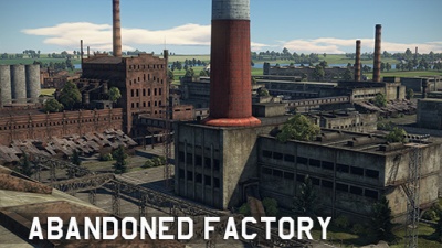
|text= ===[[File:CountryIcon_SUN.png|link=|sub]] Abandoned Factory=== | |text= ===[[File:CountryIcon_SUN.png|link=|sub]] Abandoned Factory=== | ||
| − | ''Location: | + | ''Location: USSR'' |
Located in Russia; the map consists of paved roads and a multitude of factory buildings all around, the later of which can prove useful as cover. To the south one can find a riverbank, while a small forest is located to the north. | Located in Russia; the map consists of paved roads and a multitude of factory buildings all around, the later of which can prove useful as cover. To the south one can find a riverbank, while a small forest is located to the north. | ||
| Line 25: | Line 25: | ||
|wiki= | |wiki= | ||
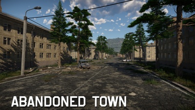
|text= ===[[File:CountryIcon_SUN.png|link=|sub]] Abandoned Town=== | |text= ===[[File:CountryIcon_SUN.png|link=|sub]] Abandoned Town=== | ||
| + | |||
| + | ''Location: USSR, Caucasus'' | ||
| + | |||
| + | The sleepy mountain town became the epicenter of outrageous military conflict. After the bombing and artillery barrage, combat vehicles enter the area. The commanders will have to achieve control over three zones of the town: the central streets and the community center, the bridge in the southern part of the town, the neighboring silo elevator and the cableway, as well as the northern area with residential buildings. | ||
| + | |||
| + | The cozy mountain towns and mining villages of the Greater Caucasus at the beginning of the 1990s became the prototypes of the Abandoned Town location. | ||
}} | }} | ||
{{Family-card | {{Family-card | ||
| Line 63: | Line 69: | ||
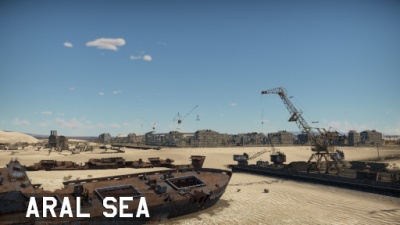
''Location: Aral Sea, pre-dissolution USSR (now between Kazakhstan and Uzbekistan)'' | ''Location: Aral Sea, pre-dissolution USSR (now between Kazakhstan and Uzbekistan)'' | ||
| + | |||
| + | Located in the Aral Sea, a once thriving sea is now a desert-like wasteland. Beached fishing ships provide some cover in the otherwise open environment, and in the middle are the ruins of a city with a bare concrete expanse that was once a dockyard. | ||
| + | }} | ||
| + | {{Family-card | ||
| + | |title= | ||
| + | |img=File:MapIcon_Ground_Arctic.jpg | ||
| + | |wiki= | ||
| + | |text= ===Arctic=== | ||
| + | |||
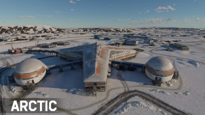
| + | ''Location: Arctic'' | ||
| + | |||
| + | Gloomy rocky islands covered with glaciers, abandoned fishing villages where lonely fishermen still live, majestic icebreakers making their way through the ice, and of course, myths and legends about secret military bases hidden in the endless icy wastelands. The Arctic is an unique area with a harsh climate, unusual landscape and the spirit of new discoveries. | ||
}} | }} | ||
{{Family-card | {{Family-card | ||
| Line 98: | Line 116: | ||
|img=File:MapIcon_Ground_Breslau.jpg | |img=File:MapIcon_Ground_Breslau.jpg | ||
|wiki= | |wiki= | ||
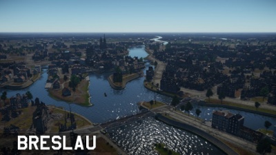
| − | |text= ===[[File: | + | |text= ===[[File:CountryIcon_NDE.png|link=|sub]] Breslau=== |
''Location: Breslau, pre-war Germany (now Wrocław, modern-day Poland)'' | ''Location: Breslau, pre-war Germany (now Wrocław, modern-day Poland)'' | ||
| Line 138: | Line 156: | ||
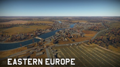
|text= ===[[File:CountryIcon_SUN.png|link=|sub]] Eastern Europe=== | |text= ===[[File:CountryIcon_SUN.png|link=|sub]] Eastern Europe=== | ||
| − | ''Location: Ukraine'' | + | ''Location: pre-dissolution USSR (now Ukraine)'' |
Located in Ukraine; Eastern Europe consists of a river-side city surrounded by hills. To the south one can find forested areas, while to the north one can find the hills surrounding. | Located in Ukraine; Eastern Europe consists of a river-side city surrounded by hills. To the south one can find forested areas, while to the north one can find the hills surrounding. | ||
| Line 158: | Line 176: | ||
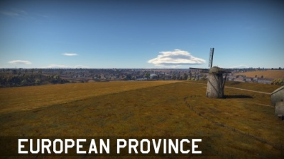
|text= ===[[File:CountryIcon_SUN.png|link=|sub]] European Province=== | |text= ===[[File:CountryIcon_SUN.png|link=|sub]] European Province=== | ||
| − | ''Location: Ukraine'' | + | ''Location: pre-dissolution USSR (now Ukraine)'' |
Located in Ukraine like Eastern Europe; European Province is an enlarged version of Eastern Europe. To the north and south, one can find a multitude of forested areas which surround large open fields while at the centre one can find the same city as in Eastern Europe. | Located in Ukraine like Eastern Europe; European Province is an enlarged version of Eastern Europe. To the north and south, one can find a multitude of forested areas which surround large open fields while at the centre one can find the same city as in Eastern Europe. | ||
| Line 208: | Line 226: | ||
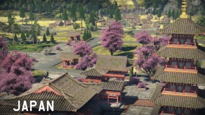
|text= ===[[File:CountryIcon_JPN.png|link=|sub]] Japan=== | |text= ===[[File:CountryIcon_JPN.png|link=|sub]] Japan=== | ||
| − | ''Location: Japan'' | + | ''Location: Fictional, Japan'' |
Located in Japan; the map consists of two small villages on each side while an imposing temple complex is located at the centre. The map is surrounded by hills and forest, with small forested and hilly areas throughout the map. | Located in Japan; the map consists of two small villages on each side while an imposing temple complex is located at the centre. The map is surrounded by hills and forest, with small forested and hilly areas throughout the map. | ||
| Line 331: | Line 349: | ||
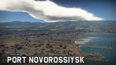
Located in Novorossiysk, Russia; the map features a mixture of urban fighting in the streets between destroyed industrial buildings in the north and south of the map, with a more open field like area in the west, and a rail yard in the middle. The map is often split into smaller areas depending on the map configuration. | Located in Novorossiysk, Russia; the map features a mixture of urban fighting in the streets between destroyed industrial buildings in the north and south of the map, with a more open field like area in the west, and a rail yard in the middle. The map is often split into smaller areas depending on the map configuration. | ||
| + | }} | ||
| + | {{Family-card | ||
| + | |title= | ||
| + | |img=File:MapIcon_Ground_Pradesh.jpg | ||
| + | |wiki=Pradesh | ||
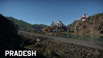
| + | |text= ===[[File:India_flag.png|42px|link=]] [[File:Pakistan_flag.png|42px|link=]] Pradesh=== | ||
| + | |||
| + | ''Location: India - Pakistan border, Himalayas'' | ||
| + | |||
| + | Here, on the border between India and Pakistan, this picturesque map lies in the foothills of the Himalayas. It features various terrain types with spaces for long-range, close-quarters, and amphibious combat amongst its rolling hills. | ||
}} | }} | ||
{{Family-card | {{Family-card | ||
| Line 336: | Line 364: | ||
|img=File:MapIcon_Ground_RedDesert.jpg | |img=File:MapIcon_Ground_RedDesert.jpg | ||
|wiki= | |wiki= | ||
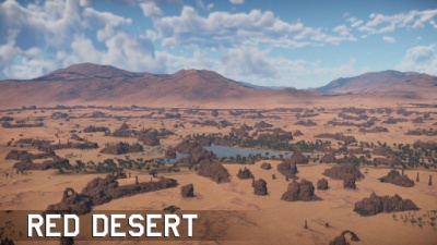
| − | |text= ===Red Desert=== | + | |text= ===[[File:Romania_flag.png|42px|link=]] Red Desert=== |
| + | |||
| + | ''Location: Ennedi Plateau, Chad'' | ||
| + | |||
| + | This location was inspired from the views of North and Central Africa, and especially the Ennedi Plateau in Chad, formed from sandstone cliffs in the Sahara desert. It is a sandstone plateau surrounded by the dunes of a great desert. A small river sources here to quickly dry up under the hot African sun. The life-giving moisture, however, is sufficient for several palm groves and majestic acacias. A small village is located In the centre of the oasis- a couple of dozen houses and a mosque. | ||
| + | |||
}} | }} | ||
{{Family-card | {{Family-card | ||
| Line 343: | Line 376: | ||
|wiki= | |wiki= | ||
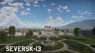
|text= ===[[File:CountryIcon_SUN.png|link=|sub]] Seversk-13=== | |text= ===[[File:CountryIcon_SUN.png|link=|sub]] Seversk-13=== | ||
| + | |||
| + | ''Location: Seversk, Russia'' | ||
| + | |||
| + | The abandoned Soviet military town of Seversk-13 and its environment is a closed city in Tomsk Oblast, Russia, located 15 kilometers northwest of Tomsk on the right bank of the Tom River. | ||
| + | |||
| + | The central zone in the location is an area near the cultural centre, surrounded by administrative and industrial buildings. It is adjacent to a residential zone of late Soviet paneled prefab buildings and a small garage cooperative. A park area with architectural objects in the style of the late 70’s flows into a suburban environment with hills and small groves. Running north to south on the location’s map, there is a section of highway that connects the north and south of the map. | ||
}} | }} | ||
{{Family-card | {{Family-card | ||
| Line 369: | Line 408: | ||
|wiki= | |wiki= | ||
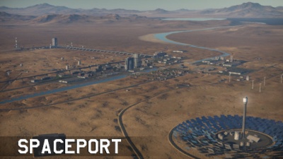
|text= ===Spaceport=== | |text= ===Spaceport=== | ||
| + | |||
| + | ''Location: Fictional'' | ||
| + | |||
}} | }} | ||
{{Family-card | {{Family-card | ||
| Line 385: | Line 427: | ||
|wiki= | |wiki= | ||
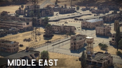
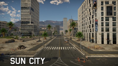
|text= ===Sun City=== | |text= ===Sun City=== | ||
| + | |||
| + | ''Location: Middle East'' | ||
| + | |||
| + | Located on the coastal regions of the Middle East, it offers a city architecture map stretching from the coast with a sun shine-filled beach in the North, a buzzing metropolis in the center, and an industrial area South. | ||
| + | |||
}} | }} | ||
{{Family-card | {{Family-card | ||
Latest revision as of 16:57, 1 March 2023
|
|
|
|
|
|
|
|
|
|
|
|
|
|
|
ArcticLocation: Arctic Gloomy rocky islands covered with glaciers, abandoned fishing villages where lonely fishermen still live, majestic icebreakers making their way through the ice, and of course, myths and legends about secret military bases hidden in the endless icy wastelands. The Arctic is an unique area with a harsh climate, unusual landscape and the spirit of new discoveries. |
|
|
|
|
|
|
|
|
|
|
|
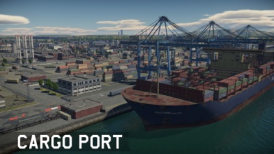
Cargo PortLocation: Fictional Cargo Port is a fictional environment based around a shipment facility. To the north one can find an airfield cut by the long highway. The middle is dominated by buildings while to the south one can find longways separated by containers. |
|
|
|
|
|
|
|
|
|
|
|
|
|
|
|
|
|
|
|
|
|
|
|
|
|
|
|
|
|
|
|
|
|
|
|
|
|
|
|
|
|
|
|
|
|
|
|
|
|
|
|
|
|
SpaceportLocation: Fictional |

|
|
|
Sun CityLocation: Middle East Located on the coastal regions of the Middle East, it offers a city architecture map stretching from the coast with a sun shine-filled beach in the North, a buzzing metropolis in the center, and an industrial area South. |
|
|
|
|
|
|
|
|
|
|
|
|
|
|
|
|
Pages in category "Ground forces maps"
The following 48 pages are in this category, out of 48 total.
