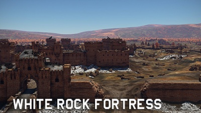
Ground forces maps

From War Thunder Wiki
Jump to: navigation, search
 
MapIcon Ground Korea.jpg

CountryIcon KOR.png 38th Parallel

Location: South Korea

Located in what is now South Korea; the map is composed of the dam to the east, which is overlooked by two cliffs, one to the north and another to the south, a military camp at the centre, which is overlooked by rice terraces to the north and south and overlooked by a rocky hill to the west, and a small village to the west, which is also overlooked by the same rocky hill.

 
MapIcon Ground AbandonedFactory.jpg

CountryIcon SUN.png Abandoned Factory

Location: USSR

Located in Russia; the map consists of paved roads and a multitude of factory buildings all around, the later of which can prove useful as cover. To the south one can find a riverbank, while a small forest is located to the north.

MapIcon Ground AbandonedTown.jpg

CountryIcon SUN.png Abandoned Town

Location: USSR, Caucasus

The sleepy mountain town became the epicenter of outrageous military conflict. After the bombing and artillery barrage, combat vehicles enter the area. The commanders will have to achieve control over three zones of the town: the central streets and the community center, the bridge in the southern part of the town, the neighboring silo elevator and the cableway, as well as the northern area with residential buildings.

The cozy mountain towns and mining villages of the Greater Caucasus at the beginning of the 1990s became the prototypes of the Abandoned Town location.

 
MapIcon Ground AdvancetotheRhine.jpg

CountryIcon NDE.png Advance to the Rhine

Location: Cologne, Germany

Located in Cologne, Germany, next to the Rhine river; Advance to the Rhine takes inspiration from the 1945 Battle for Cologne. The map consists of a destroyed urban environment and paved roads, with a park and a plaza in the middle of the map.

 
MapIcon Ground Alaska.jpg

CountryIcon USA.png Alaska

Location: Alaska, USA

Located in the most northern state of the US; Alaska presents an American urban environment complete with skyscrapers and riverbanks.

 
MapIcon Ground AmericanDesert.jpg

CountryIcon USA.png American Desert

Location: Arizona, USA

Located in Arizona, USA; American Desert represents a quiet village in the American desert. With a roundabout at the centre, the train station to one flank, and the other flank representing the outskirts of the village.

MapIcon Ground AralSea.jpg

CountryIcon SUN.png Aral Sea

Location: Aral Sea, pre-dissolution USSR (now between Kazakhstan and Uzbekistan)

Located in the Aral Sea, a once thriving sea is now a desert-like wasteland. Beached fishing ships provide some cover in the otherwise open environment, and in the middle are the ruins of a city with a bare concrete expanse that was once a dockyard.

MapIcon Ground Arctic.jpg

Arctic

Location: Arctic

Gloomy rocky islands covered with glaciers, abandoned fishing villages where lonely fishermen still live, majestic icebreakers making their way through the ice, and of course, myths and legends about secret military bases hidden in the endless icy wastelands. The Arctic is an unique area with a harsh climate, unusual landscape and the spirit of new discoveries.

 
MapIcon Ground Ardennes.jpg

CountryIcon BEL.png Ardennes

Location: Bastogne, Belgium

Located in Bastogne, Belgium; Ardennes takes inspiration from the 1944 Battle of the Bulge. The map consists of the village at its core, while the flanks consist of the outskirts with a lot of foliage to hide in.

 
MapIcon Ground AshRiver.jpg

CountryIcon IRL.png Ash River

Location: Ireland

Located in Ireland; this cliff-filled coast consists of 3 different types of environment: the mountainous west, the plain centre, and the cliffs to the east.

 
MapIcon Ground Berlin.jpg

CountryIcon NDE.png Berlin

Location: Berlin, Germany

Located in Berlin, Germany; Berlin takes inspiration from the 1945 Battle for the Reichstag, or the Battle of Berlin. At the centre one can find cover alongside a shallow river, to the west side one can fight over the ruins of the urban environment that once surrounded the Kroll Opera House, while at the east of the river one can find the imposing Reichstag which provides limited cover from the open field surrounding it. Further east one can find the Brandenburg Gate.

MapIcon Ground Breslau.jpg

CountryIcon NDE.png Breslau

Location: Breslau, pre-war Germany (now Wrocław, modern-day Poland)

 
MapIcon Ground Italy.jpg

CountryIcon ITA.png Campania

Location: Calabria, Italy

Located in Calabria, Italy; the map consists of a long city surrounded by a river to the north, hills to the east and west and another river that leads to a waterfall to the south.

 
MapIcon Ground CargoPort.jpg

Cargo Port

Location: Fictional

Cargo Port is a fictional environment based around a shipment facility. To the north one can find an airfield cut by the long highway. The middle is dominated by buildings while to the south one can find longways separated by containers.

 
MapIcon Ground Carpathians.jpg

CountryIcon POL.png Carpathians

Location: Poland

Located in the Eastern Carpathians mountains of Poland; the map consists of a large open field with some trenches dug out in the middle with, a castle located in the hills to the north and hill covered paths to the south.

 
MapIcon Ground EasternEurope.jpg

CountryIcon SUN.png Eastern Europe

Location: pre-dissolution USSR (now Ukraine)

Located in Ukraine; Eastern Europe consists of a river-side city surrounded by hills. To the south one can find forested areas, while to the north one can find the hills surrounding.

 
MapIcon Ground ElAlamein.jpg

CountryIcon GBR.png Second Battle of El Alamein

Location: El Alamein, Egypt

Located in El Alamein, Egypt; the map can be divided into three sections: to the north, the remains of a fort overlooked by cliffs located further north, a small village a top a hill in the middle, and the desert area filled with dunes to the south.

 
MapIcon Ground EuropeanProvince.jpg

CountryIcon SUN.png European Province

Location: pre-dissolution USSR (now Ukraine)

Located in Ukraine like Eastern Europe; European Province is an enlarged version of Eastern Europe. To the north and south, one can find a multitude of forested areas which surround large open fields while at the centre one can find the same city as in Eastern Europe.

 
MapIcon Ground Finland.jpg

CountryIcon FIN.png Finland

Location: Kiviniemi, pre-war Finland (now Losevo, modern-day Russia)

Located in Kiviniemi, Finland before World War II, nowadays known as Losevo, modern-day Russia; Finland presents the snowy northern landscape for which the namesake country is known. To the east one can find a small village overlooked by cliffs, while to the west one can find a forested area alongside a frozen lake, while the centre is a hilly forested area. All three areas are divided by two mountain chains on each side.

 
MapIcon Ground FrozenPass.jpg

CountryIcon NDE.png Frozen Pass

Location: Austria

Located in Austria; the map consists of a small train station alongside a tunnel inside the mountain to the south. The centre is dominated by small hills while to the north one can find a small village.

 
MapIcon Ground Fulda.jpg

CountryIcon DEU.png Fulda Gap

Location: Rasdorf, Germany

Located in Rasdorf, Germany; Fulda Gap takes inspiration from its real-life counterpart, named after the town of Fulda. The map consists of an elevated centre with forested and hilly areas while the flanks are made up of large open fields while between the southeast and central area one can find a small castle.

 
MapIcon Ground HurtgenForest.jpg

CountryIcon NDE.png Battle of Hürtgen Forest

Location: Vossenack, Germany

Located in Vossenack, Germany; Battle of Hürtgen Forest takes inspiration from its 1944 real-life counterpart. Located 5 km east of the border with Belgium, the map consists of a town at its core. To the north one can find a forested hill while to the south a shallow river stream surrounded by forested hills is located.

 
MapIcon Ground Japan.jpg

CountryIcon JPN.png Japan

Location: Fictional, Japan

Located in Japan; the map consists of two small villages on each side while an imposing temple complex is located at the centre. The map is surrounded by hills and forest, with small forested and hilly areas throughout the map.

 
MapIcon Ground Jungle.jpg

CountryIcon GBR.png Jungle

Location: Guadalcanal, Solomon Islands

Located in Guadalcanal, Solomon Islands; Jungle is inspired by the 1942 Guadalcanal campaign. The middle of the map consists a small alliance divided by shallow waters, the north, on the other hand, is dominated by the beach, while the southern area of the map is dominated by mountains.

 
MapIcon Ground Karelia.jpg

CountryIcon FIN.png Karelia

Location: Karelia, pre-war Finland (now Karelia, modern-day Russia)

Located in Karelia, Finland before World War II, nowadays modern-day Russia; Karelia is composed of a large deep canyon to the east, a rocky hill at the middle, and an open terrain to the west, the latter of which can be navigated through paths concealed by trees and small hills.

 
MapIcon Ground Kuban.jpg

CountryIcon SUN.png Kuban

Location: Krymsk, Russia

Located in Krymsk, Russia; the map is surrounded by hills and mountains. The map is divided into two sections, a Prisoner Of War camp to the east, and a hilly field in the middle and to the west. The two sections are divided by several rocky hills which overlook both areas.

 
MapIcon Ground Kursk.jpg

CountryIcon SUN.png Kursk

Location: Prokhorovka, Russia

Located in Prokhorovka, Russia; the map is composed of three areas, a flat area overlooking the river to the east, another flat area which is overlooked by hills to the west, both of which are divided by a hill in the middle. The latter contains a small village with an imposing but partially destroyed church in the middle.

 
MapIcon Ground MaginotLine.jpg

CountryIcon FRA.png Maginot Line

Location: Sedan, France

Located in Sedan, France; Maginot Line takes its namesake from the famous defensive French line bordering Germany. The map is divided into three sections, an open field to the east, overlooked by hills to the north, south and east, a large town to the west.

 
MapIcon Ground MiddleEast.jpg

CountryIcon SYR.png Middle East

Location: Syria

Located in Syria; Middle East is composed of an industrial complex to the north, which is overlooked by cliffs to the north, east and west, and a large city with damaged buildings to the south. Further south one can gaze at the mountain which overlooks the map.

 
MapIcon Ground Mozdok.jpg

CountryIcon SUN.png Mozdok

Location: Mozdok, Russia

Located in Mozdok, Russia; Mozdok is a map consisting of a river to the north, a forested hill to the east, a large plain to the south and an area containing several hills to the north. The map is often split into smaller areas depending on the map configuration.

 
MapIcon Ground Normandy.jpg

CountryIcon FRA.png Normandy

Location: Vierville-sur-Mer, France

Located in Vierville-sur-Mer, France; the map is inspired by Operation Neptune, commonly known as D-Day. The map is divided into three areas, the beach to the north, the village at the middle, which has an imposing but damaged church in the middle, and a hilly area to the south, which also makes up the northern area of the map "Fields of Normandy".

 
MapIcon Ground FieldsofNormandy.jpg

CountryIcon FRA.png Fields of Normandy

Location: Vierville-sur-Mer, France

Located in Vierville-sur-Mer, France; the map consists of the southern part of the map "Normandy". To the north one can find the same hilly area in the map Normandy to the north, meanwhile the centre is occupied by a large and imposing airship hangar in the middle. To the south, one can find a large forest to the east while the west area has several buildings that can provide cover.

 
MapIcon Ground Poland.jpg

CountryIcon POL.png Poland

Location: Poland

Located in Poland; the map is divided into three sections: the northern outskirts of the city, which is overlooked by a small forest to the north, the town southern area, which is overlooked by cliffs to the east, west and south, and the area accross the lake, which overlooks the southern part of the town. Further south, one can find forested hills which can provide cover.

 
MapIcon Ground FieldsofPoland.jpg

CountryIcon POL.png Fields of Poland

Location: Poland

Located in Poland; Fields of Poland is an enlarged version of the map "Poland". One can find an imposing mill to the north, which is overlooked by a forested hill, the town in Poland at the centre, and another imposing mill to the south which is overlooked by numerous forests.

 
MapIcon Ground PortNovorossiysk.jpg

CountryIcon SUN.png Port Novorossiysk

Location: Novorossiysk, Russia

Located in Novorossiysk, Russia; the map features a mixture of urban fighting in the streets between destroyed industrial buildings in the north and south of the map, with a more open field like area in the west, and a rail yard in the middle. The map is often split into smaller areas depending on the map configuration.

 
MapIcon Ground Pradesh.jpg

India flag.png Pakistan flag.png Pradesh

Location: India - Pakistan border, Himalayas

Here, on the border between India and Pakistan, this picturesque map lies in the foothills of the Himalayas. It features various terrain types with spaces for long-range, close-quarters, and amphibious combat amongst its rolling hills.

MapIcon Ground RedDesert.jpg

Romania flag.png Red Desert

Location: Ennedi Plateau, Chad

This location was inspired from the views of North and Central Africa, and especially the Ennedi Plateau in Chad, formed from sandstone cliffs in the Sahara desert. It is a sandstone plateau surrounded by the dunes of a great desert. A small river sources here to quickly dry up under the hot African sun. The life-giving moisture, however, is sufficient for several palm groves and majestic acacias. A small village is located In the centre of the oasis- a couple of dozen houses and a mosque.

MapIcon Ground Seversk-13.jpg

CountryIcon SUN.png Seversk-13

Location: Seversk, Russia

The abandoned Soviet military town of Seversk-13 and its environment is a closed city in Tomsk Oblast, Russia, located 15 kilometers northwest of Tomsk on the right bank of the Tom River.

The central zone in the location is an area near the cultural centre, surrounded by administrative and industrial buildings. It is adjacent to a residential zone of ​​late Soviet paneled prefab buildings and a small garage cooperative. A park area with architectural objects in the style of the late 70’s flows into a suburban environment with hills and small groves. Running north to south on the location’s map, there is a section of highway that connects the north and south of the map.

 
MapIcon Ground Sinai.jpg

CountryIcon GBR.png Sinai

Location: Southeast of Suez, Egypt

Located in the Southeast of Suez, Egypt; the map consists of a small village to the east, a large open field dividing the east and the middle area, an abandoned oil facility and military camp located on a slight hill in the middle where one can overlook west, and a small oil facility bordered by a small mountain. Further west is a small path around the mountain which also leads to the eastern part of "Sands of Sinai".

 
MapIcon Ground SandsofSinai.jpg

CountryIcon GBR.png Sands of Sinai

Location: Southeast of Suez, Egypt

Located in the Southeast of Suez, Egypt; the map consists of the western part of the region. To the far east the same abandoned oil facility, as well as the path in Sinai, are located. The latter overlooking a large village in the eastern part of the map. In the middle, one can find a number of mountains which partition the map between east and west. Westward one can find the desert area where a number of dunes provide cover for advancing units.

MapIcon Ground Spaceport.jpg

Spaceport

Location: Fictional

 
MapIcon Ground Stalingrad.jpg

CountryIcon SUN.png Stalingrad

Location: Stalingrad, Russia

Located in Stalingrad, nowadays known as Volgograd, Russia; the map is inspired on the famous World War II Battle of Stalingrad. The north-west area consists of factory complexes which have been damaged and provide places for units to hide. In the middle of the map, one can find the railway stations, further east, one can find a number of ruined apartment complexes as well as an oil complex, which is overlooked by a couple of hills further south. Further lake the frozen river provides concealed passage.

MapIcon Ground SunCity.jpg

Sun City

Location: Middle East

Located on the coastal regions of the Middle East, it offers a city architecture map stretching from the coast with a sun shine-filled beach in the North, a buzzing metropolis in the center, and an industrial area South.

 
MapIcon Ground Sweden.jpg

CountryIcon SWE.png Sweden

Location: Stockholm, Sweden

Located in Stockholm, Sweden; the map consists of a long promenade to the borders of the riverbank, westwards of the promenade there are some open parks and most notably an open area of raised land with a government-looking building and monument on it. The middle area consists of large open gardens with four large government buildings in the centre and a courtyard between them. Meanwhile, the west of the map is a largely residential area with an industrial complex with large factory buildings and storage tanks.

 
MapIcon Ground Tunisia.jpg

CountryIcon TN.png Tunisia

Location: North of Gabès, French Tunisia

Located in North of Gabès, French Tunisia; Tunisia is divided into three areas, a large city overlooking the sea to the east, a small military encampment in the middle and a large but damaged bridge to the west. The map "Sands of Tunisia" expands upon this map.

 
MapIcon Ground SandsofTunisia.jpg

CountryIcon TN.png Sands of Tunisia

Location: North of Gabès, French Tunisia

Located in North of Gabès, French Tunisia; Sands of Tunisia can be further divided into three large areas, to the east is the playable area from the map "Tunisia". In the middle a larger and more imposing bridge connects two cliffs from north to south, and to the west one can find a large village divided by the river.

 
MapIcon Ground VietnamHills.jpg

CountryIcon VNM.png Vietnam Hills

Location: Hội An, Vietnam

Located in Hội An, Vietnam; the map consists of a mountainous area to the north, which provides paths surrounded by mountains, the jungle area in the middle, and the northern outskirts of the city to the south. Further south one can find the Hội An city.

 
MapIcon Ground Volokolamsk.jpg

CountryIcon SUN.png Volokolamsk

Location: Volokolamsk, Russia

Located in Volokolamsk, Russia; the map consists of a number of scattered villages, connected by dirt roads and divided by forested hills. Between the northern and middle town, one can find a frozen lake. A ruined railway station is located in the most southern part of the map. The map is often split into smaller areas depending on the map configuration.

 
MapIcon Ground SurroundingsofVolokolamsk.jpg

CountryIcon SUN.png Surroundings of Volokolamsk

Location: Volokolamsk, Russia

Located in Volokolamsk, Russia; the map consists of the entirety of the Volokolamsk map, making it significantly larger.

 
MapIcon Ground Wallonia.jpg

CountryIcon BEL.png Wallonia

Location: Bastogne, Belgium

Located in Bastogne, Belgium; Wallonia is the enlarged version of the map "Ardennes". The north part consists of the playable area from "Ardennes". To the south-east, one can find a pair of smaller villages, each having a capture point at its centre.

 
MapIcon Ground WhiteRockFortress.jpg

CountryIcon SUN.png White Rock Fortress

Location: Brest, Belarus

The White Rock Fortress initially was built to protect the river. But as the river swallowed the fortress lost its meaning and in course of time was abandoned; only the storage buildings remained in use. As the war began the fortress was manned again and reconditioning works started. However, nothing of protective or repair works had been finished at the time it was bombed. The last of the garrison defenders have been standing against approaching enemy army.

Located in Brest, Belarus; the fort can be divided into three perimeters. The first perimeter of the form comes in the form of two ditches with a mound in-between them, running round most of the fort. Then comes the fort's outer wall, a mixture of mud and bricks, there are plenty of gaps in the wall allowing access, and a number of fortified buildings outside the wall. Finally comes the surroundings of the forts, where a large number of hills can provide cover for flanking units.