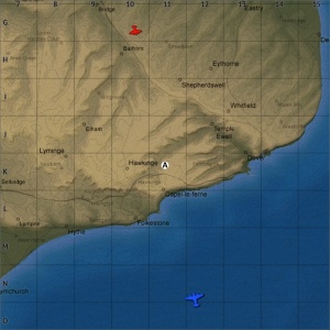
Dover Strait (Air Forces Map)
| Layouts | |||||
|---|---|---|---|---|---|
| Full flight area size | Real world location | ||||
| 128 km x 128 km | Dover Strait, England | ||||
Contents
Overview
One of the most prominent landmarks on the map is the Port of Dover, and the surrounding area. The port is a reasonably accurate (although slightly scaled down) recreation of the real life port. Dover Castle has been recreated reasonably accurately on the cliffs to the east of the town, overlooking the port. Further east Swingate transmitting station, one of Britain's "Chain Home" early warning radar installations, used to detect German aircraft crossing the channel; has been recreated (albeit with only three of its original four towers).
There are a three RAF bases (RAF Manston, RAF Hawkinge, and RAF Lympne) modelled in their real life locations. The largest, RAF Manston, is located in the north of the map on the Isle of Thanet. It is significantly larger than RAF Hawkinge and RAF Lympne, with a single 3,300m paved runway (2,700m in real life), and substantially more hangars and other building on the base. RAF Hawkinge is located 11km west of Dover; it has two grass runways, one 1100m long, the other 800m long. RAF Lympne is located 21km west of Dover, it has two grass runways, one 1100m long (1,300m in real life), the other 700m long; in game the runways are paved, in real life they were grass.
In Update 1.59 "Flaming Arrows" the Dover Strait map was added, it reused England part of this map but was extended east and south (to a size of 128km x 128km), so it include the north of France and more of the channel in the playable area.
| Game Mode | AB | RB | SB | ||||||||||||||||
|---|---|---|---|---|---|---|---|---|---|---|---|---|---|---|---|---|---|---|---|
Historical BackgroundThis map is a fictional location inspired by the Gamla Stan district of Stockholm. Although the design of the map bears resemblance to the real life location there is very little similarity between the layout of the map and that of the real Gamla Stan. Map configuration
At present this map has the same layouts in AB, RB and SB. DominationConquest
BattleNote: In this layout the northern team get two spawn points, while the southern team only get one. StrategyDescribe what focus a team should have when spawning into the map MediaThe Shooting Range #191 - Map section at 10:30 discusses the map Sweden. See also
External links
Game Modes
|
|||||||||||||||||||


